
How Aerial Photography Helps Sell Acreage and Rural Properties in Barrie, Ontario
- Apr 10
- 8 min read
Your Barrie acreage listing spans 10 acres of rolling hills, a spring-fed pond, mature hardwood forest, and a century-old farmhouse — but your MLS photos show three blurry rooms and a slightly-crooked front elevation. That mismatch isn’t just disappointing. It’s costing you showings, offers, and money.
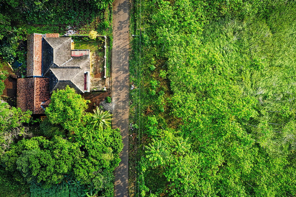
Rural and acreage properties near Barrie, Ontario are among the most challenging listings to photograph — and the most rewarding when done right. Unlike a downtown condo where a clean interior shoot is enough, an acreage property’s value lies in everything ground-level photos cannot show: the size of the land, the proximity to Lake Simcoe, the mature tree canopy, the outbuildings, the long country lane to the front door. Professional aerial drone photography is no longer a luxury for rural listings in 2026 — it’s the baseline expectation of any serious buyer.
Across Barrie, Innisfil, Oro-Medonte, Springwater, and the surrounding Simcoe County region, realtors who use aerial photography on acreage listings are seeing dramatic results: 83% more listing views, 32% faster sales, and an average of $18,000 higher sale prices compared to comparable listings with ground-only photography (NAR, 2025). In this guide, you’ll learn exactly why aerial photography matters for rural listings, what it reveals that standard photos miss, and how to use it strategically to win more offers for your Barrie sellers.
What Makes Barrie’s Rural and Acreage Market Unique?
Barrie sits at the southern tip of Lake Simcoe, roughly 90 minutes north of Toronto — a positioning that has made it one of Ontario’s most active rural real estate markets. Simcoe County consistently ranks among Canada’s fastest-growing regions (CREA, 2025), fuelled by GTA buyers seeking more land, lower prices per square foot, and a lifestyle that downtown living cannot offer.
The acreage and rural market around Barrie spans an enormous range: half-acre hobby farms in Springwater, 10-acre equestrian estates in Oro-Medonte, waterfront retreats on Lake Simcoe in Innisfil and Barrie itself, and working agricultural properties in Essa and Adjala-Tosorontio. What unites all of these properties is a shared challenge for realtors: the true value of the property is in the land, not just the building — and land is almost impossible to communicate through standard ground-level photography.
A large portion of Barrie acreage buyers are remote — coming from Toronto, Vaughan, Markham, or even out-of-province. These buyers make initial decisions based entirely on listing photos and videos. If your aerial photos don’t show the scale, the natural features, and the full layout of the property, you risk losing these buyers before they ever book a showing.
Why Standard Photography Falls Short for Rural Listings
Ground-level real estate photography was designed for residential homes with defined indoor spaces and small yard areas. It does an excellent job of showing kitchens, living rooms, and landscaped front yards. But for rural and acreage properties, ground-level photography has fundamental limitations that no amount of editing can fix.
Cannot show lot size: A 5-acre property looks identical to a 50-acre property in a front-exterior shot.
Misses natural features: Ponds, creeks, woodlots, and trails are invisible from the ground unless you’re standing directly on them.
No context of surroundings: Buyers can’t see how close the property is to neighbouring homes, roads, lakes, or towns.
Hides outbuildings: Barns, workshops, equipment sheds, and secondary structures are often not visible or appear disconnected from the main property.
Forces buyers to open Google Maps: When listing photos don’t tell the full story, buyers use Google Maps to fill in the gaps — but satellite views aren’t flattering, and buyers often move on.
“Listings with drone photography receive 83% more online views and sell 32% faster than comparable rural listings with ground-only photography.” — National Association of Realtors, 2025 Real Estate Photography Study
How Aerial Drone Photography Transforms Acreage Listings
Professional aerial drone photography does for rural listings what HDR photography does for interior rooms — it reveals the property in its best possible light and gives buyers the information they need to make a confident decision. Here’s what changes when you add drone photography to a rural listing.
Scale and Acreage Become Tangible
From above, a 10-acre property becomes a real, comprehensible thing. Buyers can see where the boundaries are, how the land lays, and what proportion of the acreage is cleared versus wooded. This single factor alone eliminates one of the most common sources of buyer uncertainty with rural properties: “Is the land actually useful, or is it all bush?”
Natural Features Become Selling Points
The pond at the back of the property that wouldn’t even appear in a standard listing? From 200 feet in the air, it becomes a centrepiece. The maple woodlot that provides privacy and maple syrup potential? Visible and beautiful from above. The creek along the north fence line? Now buyers can see it, understand it, and fall in love with it.
GTA Buyers Can Commit from a Distance
The most active segment of the Barrie rural market is GTA-based buyers who are relocating or purchasing a recreational property. These buyers often can’t visit on a whim — they need to feel confident enough to make a 90-minute drive worth their time. Aerial photography provides the spatial context and emotional connection that converts a browser into a buyer who books a showing.

What Aerial Photography Reveals That Ground Shots Miss
Air Unlimited’s Transport Canada-certified drone pilots know exactly what to capture when photographing rural and acreage listings. Here’s a breakdown of the key elements an aerial shoot covers — and why each matters to buyers.
Property boundaries: An aerial overview shows the lot shape and approximate boundaries, helping buyers understand exactly what they’re buying.
Access and infrastructure: Driveway length and condition, road access from the municipal road, hydro lines, and any right-of-ways are all visible from above.
Outbuildings and improvements: Barns, garages, sheds, workshops, grain bins, and fencing all photograph beautifully from above and communicate value immediately.
Water features: Ponds, creeks, streams, and proximity to Lake Simcoe or other bodies of water become major selling features when visible from the air.
Proximity to community: A bird’s eye view of the surrounding area shows how close the property is to Barrie, Collingwood, Orillia, or other nearby towns, which is critical for buyers weighing rural living against commute time.
Topography and drainage: Rolling hills, valleys, and slopes that create beautiful landscapes are best appreciated from above — they’re nearly impossible to convey from the ground.

Air Unlimited’s Aerial Drone Services for Barrie Realtors
Air Unlimited’s aerial drone photography service is purpose-built for the Greater Barrie and Simcoe County market. Here’s what realtors get when they book a drone shoot.
Transport Canada certified pilots — compliant with all Canadian drone regulations, including controlled airspace near Barrie’s regional airport.
High-resolution aerial stills — sharp, properly exposed 4K aerial photos optimized for MLS listings and marketing materials.
Cinematic drone video — smooth fly-around and fly-through drone footage for video walkthroughs, social media reels, and property websites.
HDR + Aerial combo packages — pair drone coverage with professional HDR interior photography for a complete listing media package.
Same-week availability — fast turnaround tailored to Barrie’s active market, with online delivery of finished files.
Air Unlimited serves all of Simcoe County and surrounding areas, including Barrie, Innisfil, Oro-Medonte, Springwater, Essa, Adjala-Tosorontio, Collingwood, Midland, Penetanguishene, Orillia, and beyond. With over 2,000 property shoots completed and 800+ five-star reviews, Air Unlimited is Barrie’s trusted choice for acreage and rural listing photography.

Tips for Getting the Most From Your Aerial Shoot
A professional drone shoot is only as effective as the preparation behind it. Here are the key factors that help Barrie realtors get maximum impact from their aerial photography sessions.
Choose the Right Season
Simcoe County’s landscape changes dramatically throughout the year. Late spring through early fall is typically the best time for aerial photography — deciduous trees are leafed out, fields are green, and the landscape looks lush and appealing. That said, winter aerials can be stunning for properties with frozen ponds, snow-covered fields, and clear sight lines through bare trees. Spring shoots just after snowmelt showcase cleared land and pond water levels. Talk to your Air Unlimited photographer about which season best showcases your specific listing.
Clear the Scene Before the Shoot
Aerial photography is unforgiving with clutter. Equipment, vehicles, construction materials, and debris are all very visible from above. Before an aerial shoot on a rural property, make sure to park vehicles out of frame, remove portable equipment from prominent areas, and wherever possible, mow or clear any visible paths and driveways. The goal is to show the land at its most intentional and appealing.
Combine Aerials With Ground-Level and Matterport
Aerial photography is most powerful as part of a complete listing media package. Pair your drone shots with HDR interior photography to cover the inside of the property, and consider adding a Matterport 3D virtual tour so remote buyers can explore the home room-by-room from anywhere in the world. For rural properties, a floor plan of the main structure is also extremely helpful for buyers trying to understand the layout of the building alongside the land.
Frequently Asked Questions About Aerial Photography for Barrie Rural Listings
How much does drone photography cost for a rural property near Barrie?
Professional aerial drone photography for rural and acreage listings near Barrie typically starts at $199–$299 as a standalone service, or is available at reduced cost when bundled with an interior HDR photography package. Contact Air Unlimited for a custom quote based on your property size and location.
Do I need special permits for drone photography on my listing in Barrie?
Your photographer handles all regulatory requirements. Air Unlimited’s pilots are Transport Canada certified under the Advanced Operations category, which allows them to fly in controlled airspace near Barrie’s regional airport and in populated areas. As a realtor or homeowner, you don’t need to arrange any permits — it’s handled entirely by the flight crew.
What’s the best time of year for aerial real estate photography near Lake Simcoe?
Late May through September is ideal for most Lake Simcoe and Barrie-area acreage properties — deciduous trees are fully leafed, the landscape is green, and the light quality is excellent during the extended golden hours. October can be spectacular for fall foliage if you have significant tree coverage on the property. Winter and early spring shoots work well for properties with open fields, wetlands, or frozen water features.
Can aerial photography help sell a property that includes a barn, shop, or farm infrastructure?
Absolutely — aerial photography is particularly valuable for properties with multiple structures. From above, buyers can immediately understand the layout and scale of the entire operation: the main house, the barn, the workshop, the grain bins, the paddocks, the fencing. This overview is nearly impossible to convey through ground-level photography alone, and it helps buyers understand the full value of what they’re purchasing.
Does Air Unlimited serve rural areas outside of Barrie?
Yes. Air Unlimited serves all of Simcoe County and surrounding regions, including Innisfil, Oro-Medonte, Springwater, Essa, Angus, Alliston, Collingwood, Midland, Penetanguishene, Orillia, and the surrounding cottage country. Call 647-905-8001 or book online to confirm coverage for your specific listing location.
Ready to Sell Your Barrie Acreage Listing Faster?
Rural and acreage listings deserve more than standard ground-level photos. Air Unlimited’s Transport Canada-certified drone pilots serve Barrie and all of Simcoe County, delivering professional aerial photography that shows buyers exactly what makes your listing special — from the boundaries to the pond to the mature hardwood at the back of the lot.
With over 2,000 property shoots completed, 800+ five-star reviews, and same-week availability across the Barrie region, Air Unlimited is the trusted choice for rural real estate photography in 2026. Book your aerial shoot today and give your listing the coverage it deserves.
Further Reading for Barrie and Ontario Realtors


Comments