
Why Every Richmond Hill Listing Needs Professional Drone Photography in 2026
- Apr 2
- 5 min read
Richmond Hill is one of York Region’s most competitive real estate markets — with an average home price above $1.4 million and listings that move fast when priced and marketed right. Yet fewer than 15% of Richmond Hill MLS listings include drone photography. That gap is a massive opportunity for realtors who want to stand out and sell for top dollar.
Professional drone photography transforms the way buyers experience a listing online. Instead of guessing at lot size or neighbourhood context, aerial shots give buyers the full picture. The data backs it up: listings with aerial media sell 68% faster and generate 403% more inquiries than those without.
In this guide, we break down why drone photography is essential for Richmond Hill realtors in 2026, what types of aerial shots work best, and how to get started with a Transport Canada-certified drone team.
Why Does Drone Photography Matter for Richmond Hill Real Estate?
Drone photography matters because it shows what ground-level photos physically cannot — the full scope of a property, its lot boundaries, and its relationship to the surrounding neighbourhood. Richmond Hill’s mix of estate homes on large lots, newer developments in Observatory Hill, and established neighbourhoods like Bayview Hill and Mill Pond makes aerial context especially valuable.
According to the National Association of Realtors, 83% of home buyers say listing photos are the most important factor in deciding which homes to tour. When those photos include aerial perspectives, engagement jumps dramatically. Listings with drone photography received 68% more online views and sold an average of 12 days faster than comparable listings without aerial images.
Listings with professional drone photography sell 68% faster and receive 403% more inquiries than those with ground-level photos alone. — NAR / Real Estate Staging Association
For Richmond Hill specifically, aerial shots showcase proximity to the Richmond Green Sports Centre, Lake Wilcox Park, the Yonge Street corridor, and the Richmond Hill GO station — all major selling points that ground-level photos cannot convey.

What Types of Drone Shots Work Best for Richmond Hill Listings?
Not all aerial shots are created equal. The most effective drone photography for Richmond Hill real estate includes a strategic mix of perspectives tailored to the property type.
Elevated Front Facade
A drone positioned 15-25 feet above ground level captures the home’s full front facade, driveway, landscaping, and roofline in a single dramatic frame. For estate homes along Bayview Avenue and in South Richvale, this elevated angle shows scale and curb appeal that street-level photos miss entirely.
Full Property Overhead
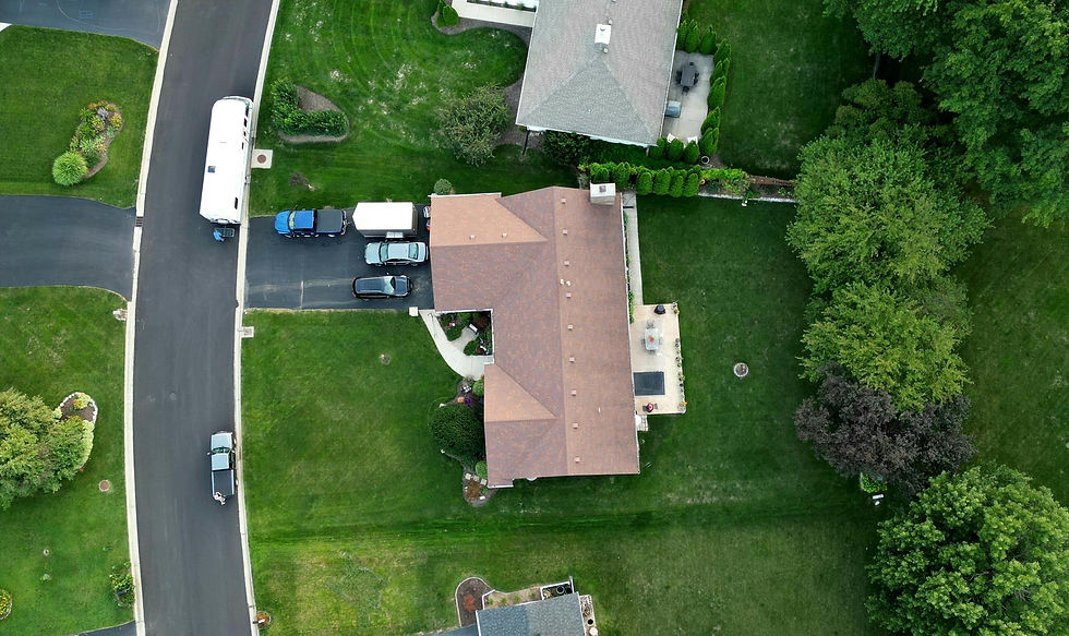
A top-down overhead shot reveals the complete lot footprint — backyard, pool, deck, garden, and property boundaries. In neighbourhoods like Oak Ridges and Jefferson where lots are generous, this perspective helps buyers understand exactly what they are getting.
Neighbourhood Context Shot
Pulling the drone back to 200-400 feet altitude provides a wider neighbourhood view showing proximity to parks, schools, and transit. This shot is especially powerful for homes near Lake Wilcox Park, Hillcrest Mall, and the Richmond Hill Centre terminal for the future Yonge North Subway Extension.
Twilight Aerial
Combining drone photography with twilight timing creates stunning dusk shots where the home glows against a dramatic sky. This premium shot type is ideal for luxury listings in Bayview Hill where warm interior lighting contrasts beautifully with the evening sky.

How Does Drone Photography Impact Sale Price in York Region?
Drone photography directly impacts the bottom line. NAR data shows homes with professional media packages sell for $3,000 to $11,000 more than comparable homes with standard smartphone photos. In Richmond Hill’s premium market where the average detached home sells for $1.6 million, that uplift represents a significant return on a media investment of just $300-$500.
The psychology is straightforward: aerial photography creates a perception of premium quality. When a buyer sees cinematic drone shots alongside professional HDR interior photography and a 3D Matterport virtual tour, they subconsciously value the property higher — even before stepping inside.
What Are Transport Canada’s Drone Regulations for Real Estate?
Flying a drone commercially in Canada requires compliance with Transport Canada’s Canadian Aviation Regulations. Operating without proper certification can result in fines up to $25,000. Here is what Richmond Hill realtors need to know when hiring a drone photographer:
The pilot must hold a valid Advanced RPAS Certificate for flights near people and buildings
The drone must be registered with Transport Canada and marked with the registration number
The pilot must carry liability insurance — a minimum of $1 million for commercial operations
Flights near Buttonville Airport require NAV CANADA authorization through the NAV Drone portal
All flights must comply with site survey requirements before every shoot
Air Unlimited’s drone photography team holds Advanced RPAS Certificates, carries full commercial insurance, and handles all Transport Canada compliance so realtors never have to worry about regulatory issues.

Which Richmond Hill Properties Benefit Most from Drone Photography?
While drone photography adds value to virtually any listing, certain property types see an outsized return:
Estate homes on large lots in Bayview Hill, South Richvale, and Mill Pond where lot size is a major selling point
Homes near premium amenities like Lake Wilcox Park, Richmond Green, or the David Dunlap Observatory lands
Properties backing onto ravines or green space in Oak Ridges and Jefferson
New construction in Observatory Hill where drone shots show the modern streetscape and community layout
Corner lots and unique configurations where the lot shape or position is a selling advantage
How to Get Started with Drone Photography for Your Richmond Hill Listings
Adding professional drone photography to your listing media package is simpler than most realtors expect. Here is the typical process with Air Unlimited:
Book your shoot — schedule online and select the drone add-on. Most Richmond Hill shoots are scheduled within 24-48 hours.
Pre-shoot preparation — our team checks airspace restrictions, weather conditions, and handles all NAV CANADA authorizations for properties near Buttonville Airport.
On-site capture — a certified drone pilot captures 10-20 aerial photos and optional video footage while the interior team shoots HDR photos simultaneously.
Professional editing — all aerial images are colour-corrected and delivered in MLS-ready resolution within 24 hours.
Full media package — combine drone shots with Matterport 3D tours, floor plans, and social media reels for a complete marketing suite.
Frequently Asked Questions
How much does drone photography cost for Richmond Hill listings?
Professional drone photography typically costs $150 to $300 as an add-on to a standard HDR photography package. When bundled with interior photos, 3D tours, and video, the per-service cost drops significantly. Check our booking page for current rates.
Is drone photography legal in Richmond Hill residential areas?
Yes, drone photography is legal when conducted by a pilot with a valid Transport Canada Advanced RPAS Certificate and proper insurance. Some areas near Buttonville Airport require additional NAV CANADA authorization. Air Unlimited handles all regulatory compliance on every shoot.
How long does a drone photography session take?
A typical drone session takes 15-30 minutes on-site, capturing 10-20 aerial photos and optional video footage. When combined with interior HDR photography, the entire shoot is usually completed within 1-2 hours. Edited images are delivered within 24 hours.
Can drones fly in winter weather in Richmond Hill?
Professional-grade drones operate in temperatures down to -10°C with reduced battery life. Winter aerial shots can be stunning — fresh snow provides clean lines and contrast. Flights are grounded during active precipitation, high winds above 35 km/h, or freezing rain.
Book Your Richmond Hill Drone Photography Shoot Today
Air Unlimited has completed over 2,000 property shoots across the Greater Toronto Area, with Transport Canada-certified drone pilots, full commercial insurance, and over 800 five-star reviews from realtors who trust our team with their listings.
Ready to elevate your Richmond Hill listings with professional drone photography? Book your shoot today or contact us to discuss a custom media package for your next listing.
Further Reading


Comments