
The Complete Guide to Real Estate Drone Photography for Edmonton Listings in 2026
- May 2
- 7 min read
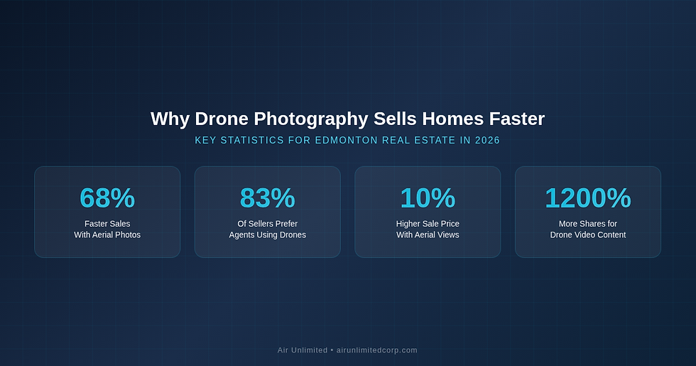
Listings with aerial imagery sell 68% faster than those without. In Edmonton’s competitive spring 2026 market — where the average detached home sits at $590,162 and median days on market dropped to just 25 in March — every advantage counts. Drone photography is no longer a luxury reserved for multi-million-dollar estates. It is a proven marketing tool that helps Edmonton realtors sell homes faster and for higher prices.
Edmonton’s unique geography makes it one of the best Canadian cities for aerial real estate photography. The North Saskatchewan River valley, sprawling suburban communities like Windermere and Terwillegar, and proximity to acreages in Sherwood Park and Spruce Grove mean that many Edmonton listings have stories that can only be told from above.
In this guide, you will learn exactly how drone photography works for Edmonton real estate, which property types benefit most, what to look for in a provider, and how to maximize your return on investment. Whether you are listing a riverfront bungalow in Riverbend or a new-build in Windermere, this guide has you covered.
Why Does Drone Photography Matter for Edmonton Real Estate?
Drone photography matters because it gives buyers a perspective they cannot get from ground-level photos alone. According to the National Association of Realtors, 83% of home sellers now prefer working with agents who use drone photography, and listings with aerial video receive 68% more inquiries than those without.
For Edmonton specifically, aerial shots accomplish three things that standard photography cannot. First, they showcase lot size and layout — critical for Edmonton’s larger suburban lots in communities like Windermere, Hawks Ridge, and Summerside. Second, they reveal proximity to parks, schools, and the river valley trail system. Third, they provide neighbourhood context that helps out-of-province buyers — particularly those relocating from Vancouver or Toronto — understand what they are getting for their investment.
Homes with professional aerial photography sell for up to 10% more and receive 1,200% more social media shares than listings with standard photos alone. — National Association of Realtors
Edmonton’s market is attracting significant interprovincial migration in 2026, with buyers drawn by affordability compared to Vancouver and Toronto. These buyers rely heavily on online listings and virtual previews. Drone photography gives your listing the visual impact needed to capture attention in a crowded digital marketplace.

What Types of Edmonton Properties Benefit Most from Drone Photography?
While virtually every listing benefits from aerial imagery, certain Edmonton property types see the greatest return on investment from drone photography.
Acreages and Rural Properties
Properties in Sherwood Park, Spruce Grove, Stony Plain, and the Parkland County corridor often sit on large lots that are impossible to appreciate from the ground. Aerial photography reveals the full scope of the land, outbuildings, fencing, and surrounding landscape. For acreage listings, professional drone photography is essentially mandatory.
Luxury and Estate Homes
Edmonton’s luxury market in neighbourhoods like Glenora, Crestwood, Westmount, and Windermere features properties with large lots, mature trees, and premium landscaping. Drone photography captures the full estate, including pools, outdoor living areas, and multi-car garages that ground-level photos cannot convey effectively.
Waterfront and River Valley Properties
Homes backing onto the North Saskatchewan River valley — in neighbourhoods like Riverbend, Terwillegar, Wolf Willow, and Belgravia — command premium prices specifically because of their proximity to the valley. Aerial photography is the only way to show this proximity in its full glory, capturing the trails, parks, and river views that make these properties special.
New Construction Communities
Buyers considering new builds in Desrochers, Cy Becker, Glenridding, or Cavanagh want to see the neighbourhood taking shape around them. Drone shots show nearby amenities, construction progress, transit access, and green spaces — information that helps buyers commit to a community that is still developing.

How Does Professional Drone Photography Work for Real Estate?
Professional drone photography for real estate follows a structured process designed to capture the best possible aerial imagery of your listing. Here is what to expect when you book a session with a Transport Canada-certified provider like Air Unlimited.
Pre-Flight Planning
Before arriving at the property, your drone photographer will review the listing location, check airspace restrictions (Edmonton has specific zones near the Edmonton International Airport and the City Centre Airport), and plan optimal flight paths. Weather conditions are assessed — wind speed, cloud cover, and lighting — to ensure the best results.
On-Site Capture
A typical real estate drone session takes 20 to 40 minutes and captures 15 to 30 aerial photos from multiple altitudes and angles. The photographer will capture straight-down overhead shots, 45-degree angle views, orbit shots around the property, and wide establishing shots that show the neighbourhood context. Many providers also capture cinematic video walkthroughs during the same session for maximum marketing impact.
Professional Editing
After the shoot, images are professionally edited for colour correction, exposure balance, and sky enhancement. The final deliverables typically include 8 to 12 curated aerial photos optimized for MLS, social media, and print marketing — plus the raw files for your records.
What Should Edmonton Realtors Look for in a Drone Photography Provider?
Not all drone photographers are created equal, and choosing the wrong provider can result in poor-quality imagery, legal liability, or both. Here are the key criteria Edmonton realtors should evaluate.
Transport Canada Certification: All commercial drone operators in Canada must hold a valid RPAS pilot certificate — either Basic or Advanced. Ask to see the certificate. Operating without one is illegal and creates liability for both the photographer and the realtor who hired them.
Insurance Coverage: Professional drone operators carry aviation-specific liability insurance, typically $1 million to $5 million. This protects you if an incident occurs during a shoot at your listing.
Real Estate Portfolio: Review their portfolio specifically for real estate work. Aerial photography of landscapes or events requires different skills than real estate. Look for consistent quality, proper exposure, and compositions that highlight property features.
Turnaround Time: In Edmonton’s fast-moving spring market, you need photos quickly. Professional providers like Air Unlimited deliver edited aerials within 24 to 48 hours of the shoot.
Bundled Services: The most cost-effective approach is bundling drone photography with other listing media. Look for providers who also offer professional HDR interior photography, Matterport 3D virtual tours, floor plans, and social media reels to maximize your marketing impact while minimizing cost.

How Much Does Drone Photography Cost for Edmonton Listings?
Standalone drone photography for a single Edmonton property typically costs between $150 and $400, depending on the size of the property, number of deliverables, and whether video is included. However, the most cost-effective approach is to bundle drone photography with your other listing media.
When you combine aerial photos with professional HDR interior photography, a Matterport 3D tour, and virtual staging, you typically save 20 to 30% compared to booking each service separately. Plus, having one provider handle everything means a single visit to the property and consistent quality across all deliverables.
Considering that Edmonton’s average detached home price is $590,162 in early 2026 and aerial photography can increase sale price by up to 10%, even the standalone cost of drone photography represents a fraction of the potential return. For a typical Edmonton listing, the ROI on professional drone photography is among the highest of any marketing investment a realtor can make.
What Drone Photography Regulations Apply in Edmonton?
Edmonton has specific airspace considerations that affect drone operations. The Edmonton International Airport and the former City Centre Airport site create controlled airspace zones where drone flights require special authorization. Additionally, flights near the Alberta Legislature grounds, military installations, and emergency scenes are restricted.
Under Transport Canada regulations, commercial drone operators must hold Advanced RPAS certification to fly in controlled airspace — which covers significant portions of Edmonton. They must also file a NAV CANADA flight plan for operations near airports. This is another reason to hire a certified professional rather than attempting DIY drone photography. A provider like Air Unlimited handles all regulatory compliance, airspace authorization, and flight planning, so you never have to worry about legal issues.
Air Unlimited’s Complete Real Estate Media Services
Air Unlimited is a Transport Canada-certified real estate media provider serving Edmonton and all of Alberta. With over 2,000 property shoots completed and 800+ five-star reviews, we deliver professional drone photography alongside a full suite of listing media services:
Professional HDR photography — stunning interior and exterior photos with perfect exposure and colour balance
Certified drone and aerial photography — capturing your listing from every angle, including overhead and orbit shots
Immersive Matterport 3D virtual tours — let buyers walk through the home remotely from anywhere in the world
Professional virtual staging — transform empty rooms into beautifully furnished spaces digitally
Accurate floor plans — detailed layouts that help buyers understand the flow and dimensions of each room
Engaging social media reels — short-form video content optimized for Instagram, TikTok, and Facebook marketing
Cinematic property videography — professionally edited listing videos with music and transitions
Frequently Asked Questions
How much does drone photography cost for an Edmonton listing?
Standalone drone photography in Edmonton typically costs $150 to $400 per property, depending on lot size and the number of photos and videos included. Bundling drone photography with other services like HDR photography and virtual tours can save you 20 to 30% compared to booking each separately.
Is drone photography legal for real estate in Edmonton?
Yes, drone photography is legal for real estate in Edmonton when conducted by a Transport Canada-certified operator with proper insurance and airspace authorization. Parts of Edmonton fall within controlled airspace near the Edmonton International Airport, so Advanced RPAS certification and NAV CANADA flight plans may be required. Always hire a certified professional to ensure compliance.
Do I need drone photos for every Edmonton listing?
While aerial photos benefit almost every property type, they deliver the strongest ROI for acreages, luxury homes, waterfront properties, and listings in new construction communities. That said, even standard suburban homes benefit from aerial neighbourhood context shots that show proximity to parks, schools, and transit.
How long does a drone photography session take?
A typical real estate drone session takes 20 to 40 minutes on site. When combined with interior photography, the entire shoot is usually completed within 60 to 90 minutes. Edited photos are typically delivered within 24 to 48 hours.
What happens if the weather is bad on shoot day?
Professional drone operators monitor weather forecasts closely and will reschedule if conditions are unsafe — high winds, rain, or heavy snow prevent safe drone operations. Edmonton’s weather can change quickly, so experienced providers like Air Unlimited build flexibility into their scheduling to accommodate Alberta’s unpredictable conditions.
Book Your Edmonton Drone Photography Session
Ready to give your Edmonton listings the aerial advantage? Air Unlimited’s Transport Canada-certified drone pilots serve Edmonton, Sherwood Park, St. Albert, Spruce Grove, Leduc, and all surrounding communities. With over 2,000 property shoots completed and 800+ five-star reviews, we deliver professional drone photography alongside complete listing media packages — all with 24 to 48 hour turnaround.
Book your shoot today or call us at 647-905-8001 to discuss your listing needs.
Further Reading
Learn more: Why Accurate Floor Plans Close Deals Faster — A Guide for Edmonton Realtors
Related: How Aerial Photography Helps Sell Acreage and Rural Properties in Barrie, Ontario
Explore: Real Estate Photography for New Construction Projects in Saskatoon
Discover: How Professional Photos Help Realtors Win More Listings in Vaughan

Comments