

How Drone Photography Sells Waterfront and Lakefront Properties Faster in Thunder Bay, Ontario
A waterfront listing in Thunder Bay can lose buyers in the first three seconds — not because of the home, but because ground-level photos hide the one thing buyers are paying for: the water.
When a property sits on Lake Superior, the Kaministiquia River, or one of the dozens of lakes around the city, the shoreline, the dock, the lot size, and the privacy are the value. A standard photo taken from the deck simply can't show any of it. That is exactly the gap professional drone photography fills.
Aerial imagery has shifted from a luxury add-on to a baseline expectation for waterfront and rural listings across Northwestern Ontario. In this guide, we break down why drone photography sells lakefront homes faster in Thunder Bay, what the data says about buyer behaviour, the Transport Canada rules every realtor should know, and how to make the most of every flight.

What This Guide Covers
Why waterfront listings need aerial photography
What the data says about drone photos and sale speed
How drone shots reveal value ground photos miss
Transport Canada drone rules in Thunder Bay
Best conditions for shooting lakefront properties
How to pair drone media with other listing tools
Frequently asked questions
Why Do Waterfront Listings in Thunder Bay Need Drone Photography?
Because the water is the product — and only an aerial view can show it. For a lakefront home, buyers are not just purchasing square footage; they are buying frontage, a view, a shoreline, and a setting. Ground-level photography captures the building but crops out the very feature that justifies the price.
Thunder Bay's market is built on this kind of property. Listings along the Lake Superior shoreline, cottages around Loon Lake and Hawkeye Lake, riverfront homes on the Kaministiquia, and acreage in surrounding townships like Shuniah and Oliver Paipoonge all share the same challenge: the most valuable feature is outside the walls. Drone photography is the only practical way to show a buyer the full extent of what they would own.
There is also a discovery problem. Most buyers — including the relocation buyers drawn to Thunder Bay for healthcare, education, and resource-sector jobs — start their search online and often from out of town. They may never drive past the property before deciding whether to book a showing. An aerial photo that shows the home in its landscape does the job an in-person drive-by used to do.
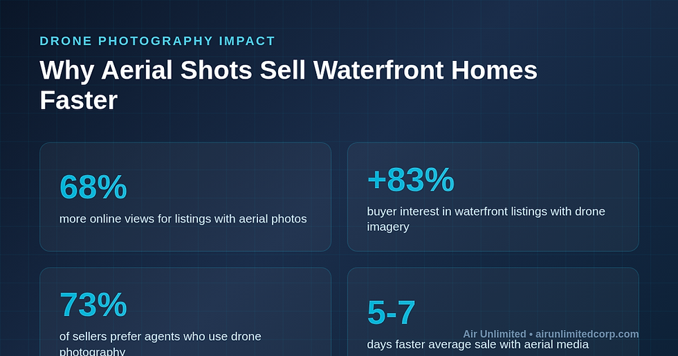
Listings that include aerial imagery receive up to 68% more online views than comparable listings with ground photos alone. For waterfront homes, where the setting is the selling point, that gap is even wider.
How Much Faster Do Homes With Aerial Photos Actually Sell?
Listings with professional aerial photography tend to sell several days faster and attract significantly more qualified interest than those without. The effect is strongest exactly where Thunder Bay lives: waterfront, rural, and large-lot properties.
Industry research has consistently found that homes marketed with drone imagery sell faster than comparable listings using only ground photos, with some studies citing sales up to 68% quicker for properties where aerial views add genuine context. The reason is simple — buyers self-select. Someone who sees the full shoreline, the tree cover, and the distance to neighbours arrives at the showing already informed and more serious.
That filtering effect matters in a market like Thunder Bay, where waterfront and acreage buyers are often travelling from Toronto, Winnipeg, or out of province. Fewer wasted showings and better-qualified inquiries translate directly into shorter days on market and cleaner offers.

What Can Drone Photography Show That Ground Photos Can't?
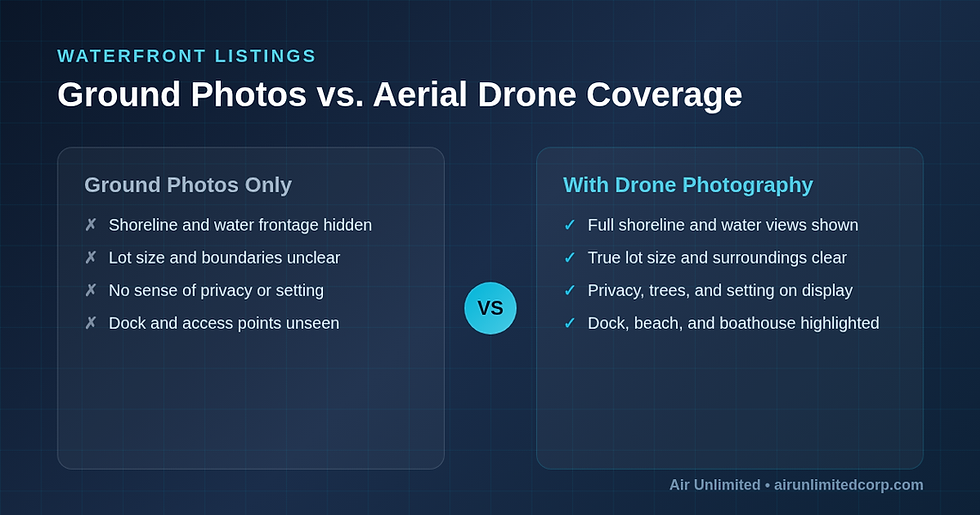
Aerial photography reveals the four things waterfront buyers care about most: the water frontage, the true lot size, the privacy of the setting, and the access points like docks and beaches. None of these read clearly from ground level.
The Full Shoreline and Water Frontage
A drone shot taken from 30 to 60 metres up shows exactly how much shoreline a property has, whether the water is sandy or rocky, and how the home is oriented to the lake. On Lake Superior, where frontage and exposure drive value, this single image often does more selling than the entire interior gallery.
True Lot Size and Boundaries
Rural and acreage listings around Thunder Bay are hard to grasp from the ground. An overhead view communicates the size of the parcel, the layout of outbuildings, the driveway, and how the land meets the water — context that helps buyers understand the price.
Privacy and Setting
For cottage and waterfront buyers, privacy is a top priority. Aerial imagery shows the buffer of trees, the distance to the nearest neighbour, and the natural setting in a way that a fenced-yard photo never can.
Docks, Beaches, and Access
The dock, the boathouse, the beach, the boat launch — these features are central to a waterfront sale and are almost invisible in ground photography. A drone frames them as part of the whole package.
Is Drone Photography Legal for Real Estate in Thunder Bay?
Yes — but it must be flown by a pilot certified by Transport Canada. Commercial real estate drone work in Canada requires a valid Drone Pilot Certificate and a registered aircraft, and certain airspace around Thunder Bay carries extra rules.
Under Canada's Remotely Piloted Aircraft System regulations, anyone flying a drone for commercial purposes (including real estate marketing) must hold the appropriate Transport Canada certificate, register the drone, and follow operating rules on altitude, distance from bystanders, and airspace. Thunder Bay International Airport (YQT) sits within the city, which means parts of the area fall inside controlled airspace where flights require authorization.
This is why hiring a certified provider matters. Air Unlimited's drone and aerial photography is flown by Transport Canada–certified pilots who handle airspace authorizations, carry liability insurance, and know how to operate safely and legally around the airport and the lakeshore. A realtor who books a certified operator is protected; one who relies on an unlicensed hobbyist is exposing themselves to fines and liability.
When Is the Best Time to Shoot a Lakefront Property in Thunder Bay?
The best aerial shots come from calm, clear conditions with the sun low enough to add depth but high enough to light the water — typically mid-morning or the golden hour before sunset, on a day with light wind.
Thunder Bay's seasons each offer something different. Summer delivers blue water, full tree canopy, and long daylight — ideal for showing a property at its most inviting. Fall brings dramatic colour along the shoreline and across the Nor'Wester Mountains in the background. Even winter has a place: a frozen lake and snow-covered acreage can communicate scale and beauty for the right buyer, though footing and battery performance require an experienced pilot.
Wind is the biggest variable on the big lake. Lake Superior can shift quickly, and gusts affect both flight stability and water surface. A local, certified operator plans the flight window around the forecast — something a one-off hobbyist rarely does.

How Should Realtors Combine Drone Photography With Other Listing Tools?
Aerial photography works best as part of a complete media package. For a waterfront or rural Thunder Bay listing, the strongest results come from pairing drone shots with interior photography, video, and a floor plan so buyers understand both the setting and the home.
A high-performing waterfront listing in Thunder Bay typically combines:
Professional HDR interior photography so the inside matches the quality of the aerial exterior shots
Aerial drone photography and video to showcase the shoreline, lot, and setting
A cinematic property video walkthrough that blends ground and aerial footage into one story
An accurate floor plan so out-of-town buyers can picture the layout before travelling
Short social media reels that lead with the most striking aerial shot to stop the scroll
Used together, these tools do the work of an in-person visit for the many buyers searching from outside the region — and they position the listing agent as the local professional who markets waterfront homes properly.
Frequently Asked Questions
How much does real estate drone photography cost in Thunder Bay?
Aerial photography for a residential listing in Thunder Bay typically ranges from about $150 to $400 depending on the property size, whether video is included, and how it is bundled with interior photography. Waterfront and acreage properties may sit at the higher end because they require more flight time and careful planning around airspace and wind. Booking aerial work as part of a full media package is usually the most cost-effective option.
Do you need a licence to fly a drone for real estate in Canada?
Yes. Flying a drone for any commercial purpose in Canada, including real estate marketing, requires a Transport Canada Drone Pilot Certificate and a registered aircraft. Parts of Thunder Bay near the airport are controlled airspace and need authorization. Always hire a certified operator who carries insurance.
Is drone photography worth it for non-waterfront homes?
Often, yes. Even for a standard city lot in Thunder Bay, an aerial shot can show proximity to parks, schools, the waterfront, or amenities, and it helps a listing stand out in search results. The return is greatest for waterfront, rural, and large-lot properties, but a single establishing aerial shot adds value to most listings.
Can drones be flown in winter in Thunder Bay?
Yes, with an experienced pilot. Cold temperatures reduce battery life and snow affects visibility, but winter aerials of a frozen lake or snow-covered acreage can be striking. A certified local operator plans for the conditions and keeps flights safe and legal year-round.
How quickly can I get aerial photos back for my listing?
Most providers deliver edited aerial photos within 24 to 48 hours of the shoot. Air Unlimited offers fast turnaround so your Thunder Bay listing can go live quickly while buyer interest is at its peak.
Ready to Sell Your Thunder Bay Waterfront Listing Faster?
If your listing sits on Lake Superior, a river, or a lake anywhere around Thunder Bay, aerial photography is the single fastest way to show buyers what makes it valuable. Air Unlimited's Transport Canada–certified pilots have completed over 2,000 property shoots across Canada, backed by more than 800 five-star reviews and full liability insurance.
Book your professional drone shoot today at airunlimitedcorp.com/bookings and give your waterfront listing the marketing it deserves.
Further Reading


Comments